


Showing posts with label Places. Show all posts
Showing posts with label Places. Show all posts
Sunday, March 24, 2013


Friday, January 25, 2013
Udawalawe National Park


Wednesday, January 23, 2013
Tangalle
Tangalle (Sinhala තංගල්ල [ˈtaŋɡalːə]) is a big town in Hambantota District, Southern Province, Sri Lanka, governed by an Urban Council.
It is one of the largest towns in southern province. It has a mild
climate, in comparison to the rest of the district, and sandy beaches.
The name of the town in Sinhala means "projected rock", a reference to the rocks which form the coastline in the town area, which contrasts with the sandy beach of the surrounding areas.


 Tangalle is a regionally important fishing port and a centre of tourism. In the city center there is an old Dutch fort which is used as a prison today.
The name of the town in Sinhala means "projected rock", a reference to the rocks which form the coastline in the town area, which contrasts with the sandy beach of the surrounding areas.


Sinharaja Forest Reserve

 The hilly virgin rainforest, part of the Sri Lanka lowland rain forests ecoregion,
was saved from the worst of commercial logging by its inaccessibility,
and was designated a World Biosphere Reserve in 1978 and a World
Heritage Site in 1988. The reserve's name translates as Kingdom of the Lion.
The hilly virgin rainforest, part of the Sri Lanka lowland rain forests ecoregion,
was saved from the worst of commercial logging by its inaccessibility,
and was designated a World Biosphere Reserve in 1978 and a World
Heritage Site in 1988. The reserve's name translates as Kingdom of the Lion.The reserve is only 21 km (13 mi) from east to west, and a maximum of 7 km (4.3 mi) from north to south, but it is a treasure trove of endemic species, including trees, insects, amphibians, reptiles, birds and mammals.
 Because of the dense vegetation, wildlife is not as easily seen as at dry-zone national parks such as Yala. There are about 3 elephants and the 15 or so leopards are rarely seen. The most common larger mammal is the endemic Purple-faced Langur.
 An interesting phenomenon is that birds tend to move in mixed feeding flocks, invariably led by the fearless Greater Racket-tailed Drongo and the noisy Orange-billed Babbler. Of Sri Lanka's 26 endemic birds, the 20 rainforest species all occur here, including the elusive Red-faced Malkoha, Green-billed Coucal and Sri Lanka Blue Magpie.
Reptiles include the endemic Green pit viper and Hump-nosed vipers, and there are a large variety of amphibians, especially tree frogs. Invertebrates include the endemic Common Birdwing butterfly and the inevitable leeches
Hummanaya Blowhole - Tangalle


A blowhole is also the name of a rare geologic feature in which air is blown through a small hole at the surface due to pressure differences between a closed underground system and the surface. The blowholes of Wupatki National Monument are an example of such a phenomenon. It is estimated that the closed underground passages have a volume of at least seven billion cubic feet. Wind speeds can approach 30 miles per hour.[2]
Pinnawala Eliphant Orphanage


Horton Plains National Park


Horton Plains National Park is a protected area in the central highlands of Sri Lanka and is covered by montane grassland and cloud forest. This plateau at an altitude of 2,100–2,300 metres (6,900–7,500 ft) is rich in biodiversity and many species found here are endemic to the region. This region was designated a national park in 1988. It is also a popular tourist destination and is situated 32 kilometres (20 mi) from Nuwara Eliya and 8 kilometres (5.0 mi) from Ohiya

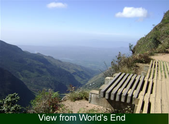
The Horton Plains are the headwaters of three major Sri Lankan rivers, the Mahaweli, Kelani, and Walawe. In Sinhala the plains are known as Maha Eliya Plains. Stone tools dating back to Balangoda culture have been found here. The plains' vegetation is grasslands interspersed with montane forest, and includes many endemic woody plants. Large herds of Sri Lankan Sambar Deer feature as typical mammals, and the park is also an Important Bird Area with many species not only endemic to Sri Lanka but restricted to the Horton Plains. Forest dieback is one of the major threats to the park and some studies suggest that it is caused by a natural phenomenon. The sheer precipice of World's End and Baker's Falls are among the tourist attractions of the park.


Sunday, December 30, 2012
Polonnaruwa


- Polonnaruwa (Sinhalese - පොළොන්නරුව Tamil - பொலநறுவை or புளத்தி நகரம் as called by Cholas) is a town. It's the main town of Polonnaruwa District in the North Central Province, Sri Lanka. Kaduruwela area is the Polonnaruwa New Town and the other part of Polonnaruwa, remains as th
The second most ancient of Sri Lanka's kingdoms, Polonnaruwa was first declared the capital city by King Vijayabahu I, who defeated the Chola invaders in 1070 to reunite the country once more under a local leader.
e royal ancient city of polonnaru kingdom.
Tuesday, December 25, 2012
Kumana National Park (Bird Santuary)

Kumana National Park in Sri Lanka is renowned for its avifauna, particularly its large flocks of migratory waterfowl and wading birds. The park is 391 kilometres (243 mi) southeast of Colombo on Sri Lanka's southeastern coast. Kumana is contiguous with Yala National Park. Kumana was formerly known as Yala East National Park, but changed to its present name in 5 September 2006.

Jaya Sri Maha Bodhi

j
Saturday, December 8, 2012
Anuradhapura - Ancient City
Anuradhapura


Anuradhapura, (අනුරාධපුරය in Sinhala, அனுராதபுரம் in Tamil) is a major city in Sri Lanka. It is the capital city of North Central Province, Sri Lanka and the capital of Anuradhapura District. Anuradhapura is one of the ancient capitals of Sri Lanka, famous for its well-preserved ruins of ancient Sri Lankan civilization. It was 3rd capital of the Kingdom of Rajarata after Tambapanni and Upatissa Nuwara.
The city, now a UNESCO World Heritage Site, lies 205 km north of the current capital Colombo in Sri Lanka's North Central Province, on the banks of the historic Malvathu Oya. It is one of the oldest continuously inhabited cities in the world and one of the eight World Heritage Sites of Sri Lanka.
From the 4th century BC, it was the capital of Sri Lanka until the beginning of the 11th century AD. During this period it remained one of the most stable and durable centers of political power and urban life in South Asia. The ancient city, considered sacred to the Buddhist world, is today surrounded by monasteries covering an area of over sixteen square miles (40 km²).
Thursday, November 22, 2012
Ella, Sri Lanka
Ella - Sri Lanka


Sunday, November 18, 2012
Mirissa Beach
Mirissa Beach
Sri Lanka has been known by many names over the centuries. During the
years under the British occupation is was known as Ceylon and many years
before that it was called Serendib, a word now used to describe utter
tranquility and relaxation.


Wednesday, November 14, 2012
Dalada Maligawa - Sri Lanka


Tuesday, November 13, 2012
Arugam Bay, Ullae (Pottuvil, Sri Lanka)
Arugam Bay, Ullae (Pottuvil, Sri Lanka)

A small fishing village up to recently only known to some die hard
surfers. For which AbaY counted as Asia's Surfing Mecca, ever since the
1960s. Due to Sri Lanka's long civil war this remote half moon shaped
Bay has been almost unknown to any other visitors and tourists. The
consistent swell, long runs, shark free, permanently warm (28C) crystal
clear waters, relaxed life onshore and budget accommodation however has
elevated Arugam Bay onto the international surfer's map. In June 2010
ASP (Association of Surfing Professionals) held a successful
international competition at A-Bay – as it's known – which was won by
Australian Julian Wilson..
Arugam Bay is often mentioned to be in the top 10 of the world's surf
spots, due to a basket of favorable factors. The average wave height
however rarely exceeds 3–4 Meters. Most of the resort was wiped off in
the 2004 Tsunami when AbaY suffered a direct hit by a 16–18 Meter wave,
caused by its long coral reef located at the Main Surf Point also known
as "Upali's" point. Other known surf breaks nearby are Pottuvil Point,
Whisky Point, Okanda Bay, Panama, Green Room, Urani. "Arugam Surf" is
Sri Lanka's first and rather remarkable, popular Facebook page with
27,000 fans giving almost daily updates of relevant events from the Bay
itself.
from wikipedia
Subscribe to:
Posts (Atom)


